
by Nick Law
GIS (Geographic Information System) technology provides several benefits to the commercial real estate industry. Here are some ways in which GIS technology can be advantageous:
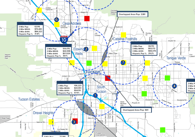
1. Site Selection and Market Analysis: GIS enables commercial real estate professionals to analyze and evaluate potential sites for various purposes, such as retail locations, office spaces, or industrial developments. By integrating geospatial data like demographics, traffic patterns, consumer behavior, and market trends, GIS can help identify areas with high growth potential, target specific customer segments, and make informed decisions on property investments.
2. Spatial Visualization: GIS allows commercial real estate stakeholders to visually represent property data on maps, enhancing their understanding and decision-making processes. Maps can display property boundaries, zoning information, infrastructure, transportation networks, and nearby amenities. This visual representation aids in identifying relationships and patterns, highlighting opportunities, and communicating complex information more effectively.
3. Portfolio Management: GIS technology facilitates the management and analysis of commercial real estate portfolios. Property locations, leasing information, occupancy rates, and financial data can be integrated into GIS platforms, providing a comprehensive view of the portfolio. This enables real estate professionals to identify underperforming assets, assess risk exposure, optimize leasing strategies, and make data-driven decisions to maximize returns.
4. Market Intelligence and Competitive Analysis: GIS can be used to gather and analyze market data, including property sales and lease transactions, property values, vacancy rates, and rental rates. By overlaying this data on maps, commercial real estate professionals can identify emerging market trends, assess competition, and gain insights into market dynamics. This information helps in formulating pricing strategies, negotiating deals, and staying ahead of the competition.
 5. Risk Assessment and Due Diligence: GIS technology assists in assessing and managing risks associated with commercial real estate investments. It can integrate data on natural hazards (flood zones, seismic activity), environmental factors (contamination, protected areas), and regulatory constraints (zoning, building codes). This enables real estate professionals to evaluate potential risks, ensure compliance, and make informed decisions regarding property acquisitions or developments.
6. Marketing and Visualization: GIS enhances the marketing efforts of commercial real estate professionals by creating visually appealing and informative property presentations. Interactive maps, 3D visualizations, and virtual tours can be developed using GIS technology, providing potential investors or tenants with a better understanding of the property’s location, surroundings, and amenities.
Overall, GIS technology empowers commercial real estate professionals with spatial analysis, market insights, and informed decision-making, leading to improved site selection, optimized portfolio management, and enhanced marketing strategies.